Speed Zone 5:
Sacramento River Canyon to Dunsmuir
As soon as the Shasta Lake realignment ends, the train is greated with a special welcome message: Curves of 546 feet radius. With the parameters, that are assumed for mixed operation with heavy freight in this article, this means a speed restriction to 37 mph.
The bad news: Such curves, or at least curves of 574 feet radius, are standard within this speed zone.
"Old alignment of the 1880s" is the usual explanation for this, but not the full story. Lots of contemporary track has been built differently, cutting through a river knee with a short tunnel here, bridging to the better side of the river there. Result hasn't been highspeed tracks, but at least, today's tilting trains can sqeeze quite some speed out of those alignments. South of Dunsmuir, the Sacramento River Canyon would have been well suited to this approach.
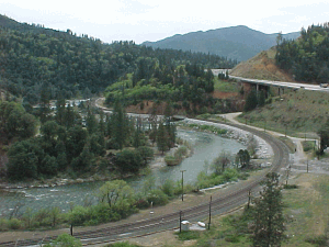
The curvature at Lamoine cannot be explained by "1880s" alone. Better solutions for this situation were available even back
then.
The extremely tight curvature has had additional reasons:
-
Not enough population to pay back high investment.
Tight curvature was already explained as a logical result of US railroad history in this article. The Shasta Route connects California and Oregon. When the construction of the railroad started, the whole state of Oregon had about 150.000 inhabitants. In 1880, it was 175000. Completing the railroad helped to reach 320000 in 1890. In 1900, there were 415000 inhabitants of Oregon.
-
Business of that time looked like temporary business.
Along the line, main business activities were small-scale mining and the timber industry. The economy of those days was based on timber as construction material, and sawmills sprang up all along the line, as soon as it was completed. A 19th century timber industry shouldn't be imagined like a modern one, though. Instead of protecting future income, this was a business on the move, harvesting logs along its way. (Follow this link to a contemporary critical view of the 1880s logging in the Shasta region.) A business on the move does not fit to high investment into a fixed plant.
-
Lack of funds.
The "Oregon and California Rail Road" ran out of cash, before the Shasta Route was finished. A general economic crisis situation, and fund mishandling contributed to this, but without doubt, such circumstances favour cheap solutions.
-
The curvy layout achieved a ruling grade of 1.27%.
The operating concept of the 1880s was based on a long stretch of moderate grade, a pusher loco attachment point, and a final climb. The attachment point created a railroad settlement, which was called "Pusher" and later renamed to "Dunsmuir". Route layout and operating concept are best assumed to have been one plan, targeted at cost reduction under contemporary circumstances.
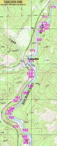
Another view on the Lamoine curves, this time on a topo map.
There are some stretches of track, that allow faster operation, but these are just a few miles long. Therefore, a realistic approach is, to assume a steady 37 mph run for this speed zone, and sum up the speedup possibilities for the punctuality buffer time.
If you are an UP engineer, and operate trains on this route, you will shake your head, when reading "speedup possibilities". Consider this:
- Length of this train is less than 1/10 of a freight.
- Acceleration is as good as for a freight engine with one half-loaded freight car behind.
This speed zone is one of those parts, where an out-of-the-box Talgo is unusable. In order to avoid excessive sway in station throats with several crossovers in rapid succession, the tilting mechanism is normally blocked below 43.5 mph. In the Sacramento River Canyon, this feature is a bug, and needs an override function for the engineer, or an automatic override.