Speed Zone 6: Sacramento River Canyon - the climb

Dunsmuir to Azalea

Behind Dunsmuir, the track geometry does not improve. Standard curve radius is still the same: 574 feet. Three things are different, though:

  1. Before reaching the sidings on top of the hill, there is no possibility for speedup at all.
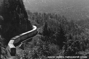
  2. Instead, there is a slowdown point: Curve No. 579 "Cantara Loop", with a radius of 410 feet. The defined example trains could go through this loop at 32 mph.
  3. Ruling grade is 2.2%. While running uphill at 38 mph is an easy task for the defined passenger trains, it means very slow freights and additional helper movements, lowering line capacity within this speed zone.

Doubledeck passenger train climbs in s-curves, along the precipice towards a tree-covered valley.
38 mph would be the speed limit for this climb. Amtrak's "Coast Starlight" is slower.

The only thing to advertise about this piece of track is: Great views. One hundred years ago, this wasn't just great, but a major commercial advantage. Southern Pacific transported lots of tourists to the Sacramento River Canyon, and two special stations were located between Dunsmuir and Azalea: Shasta Retreat and Shasta Springs. Shasta Springs, accessible only by railroad, is gone. Shasta Retreat does not have a station today.

Topo map of this speed zone.
In comparison to the Interstate 5, the train looses lots of time in this part of the route.

"Three hours and a quarter" from Sacramento to Dunsmuir would be a good offer for tourists again. Expecting a considerable number of customers is realistic. But large scale railroad-based tourism, as in the grand history of this line, will never return.

Achievable timing
Station or MP Distance ...added up  Time elapsed Coast Starlight Average speed ...added up
Azalea 11 miles (18 km) 227 miles (365 km) 00:21 03:35 - 32 mph (52 km/h) 63 mph (102 km/h)
Dunsmuir 0 216 miles (348 km) 00:01 03:14 05:05 - 67 mph (108 km/h)
Dunsmuir 26 miles (42 km) 216 miles (348 km) 00:44 03:13 ??:?? 36 mph (58 km/h) 67 mph (108 km/h)
MP 296 30 miles (48 km) 189 miles (304 km) 00:36 02:30 - 51 mph (82 km/h) 76 mph (122 km/h)
Redding 0 159 miles (256 km) 00:02 01:54 03:15 - 84 mph (135 km/h)
Redding 25 miles (40 km) 159 miles (256 km) 00:17 01:52 ??:?? 89 mph (143 km/h) 85 mph (137 km/h)
MP 233 10 miles (16 km) 134 miles (216 km) 00:09 01:35 - 68 mph (109 km/h) 84 mph (135 km/h)
Red Bluff 0 124 miles (200 km) 00:01 01:27 - - 86 mph (138 km/h)
Red Bluff 39 miles (63 km) 124 miles (200 km) 00:26 01:26 - 91 mph (146 km/h) 87 mph (140 km/h)
Chico 0 85 miles (136 km) 00:01 01:00 01:56 - 85 mph (137 km/h)
Chico 44 miles (71 km) 85 miles (136 km) 00:29 00:59 ??:?? 91 mph (146 km/h) 87 mph (140 km/h)
Marysville WP 0 41 miles (66 km) 00:02 00:30 - - 86 mph (138 km/h)
Marysville WP 41 miles (66 km) 41 miles (66 km) 00:28 00:28 - 90 mph (145 km/h) 90 mph (145 km/h)
Sacramento 0 0 00:00 00:00 00:00 0 mph 0 mph

The author does not have any upgrade suggestion for this piece of track, short of building a bypass from Dunsmuir to Azalea. The existing grade, including the long detour, is 2.2%. The Interstate 5, which uses a cutoff at this place, is 5% steep, with some sections of 3%.

Conclusion: Such approach would need as steep a climb as on European highspeed lines. Such a line is almost unusable for freight. At Dunsmuir, this would result in high cost for a low number of trains.


Unit conversion for text on this page.
574 feet radius 175 m radius 10 degrees of curvature
410 feet radius 125 m radius 14 degrees of curvature
32 mph 51.5 km/h  
38 mph 61 km/h  

about this document            Hans-Joachim Zierke            © notice