Speed-Zone 8:
Black Butte to Edgewood

This section has the same tight curvature as the Sacramento River Canyon. Higher average speeds than in the canyon are a result of the different operating strategy, suggested for the Siskiyou Line and its low amount of freight: More superelevation, more unbalanced superelevation, less buffer time.

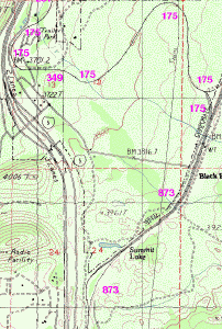
The curvature has to be explained by the effort of 1880, to restrict the grade to 2.2%. There were no natural obstacles, which could have outruled a straighter alignment in this roomy valley. By snaking along the curvy sides of the valley, much of the descending could be done without the erection of dams. 25 years later, the sawmill of Abner Weed took advantage of the railroad, and the workers settled in a loop of the track. Long-Bell Lumber Co. made Weed a regional center of railroad operation, with a network of logging railroads around its mill.

Aerial view of Weed in 1946.
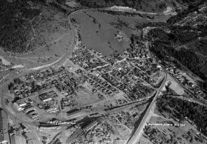
Weed in the days of Long-Bell Lumber Co.

While Oregon timber is still the most important load of the daily freight train to Black Butte, the golden days of the industry are over, and with it, the numerous long freights on the Siskiyou Line. Weed defines itself as a retirement community today. Its population has decreased, but due to its history, it is well located in the traffic network. In addition, speed is restricted by the track loop in Weed, reducing the time lost by a stop. Therefore, it is suggested to use Weed as a station again.

Achievable timing
Location Distance ...added up  Time elapsed Coast Starlight Average speed ...added up
Edgewood 5 miles (8 km) 248 miles (399 km) 00:07 04:03 - 43 mph (69 km/h) 61 mph (98 km/h)
Weed 0 243 miles (392 km) 00:01 03:56 - - 62 mph (99 km/h)
Weed 4 miles (7 km) 243 miles (392 km) 00:06 03:55 - 42 mph (68 km/h) 62 mph (100 km/h)
Black Butte 12 miles (19 km) 239 miles (385 km) 00:14 03:49 - 52 mph (84 km/h) 63 mph (101 km/h)
Azalea 11 miles (18 km) 227 miles (365 km) 00:21 03:35 - 32 mph (52 km/h) 63 mph (102 km/h)
Dunsmuir 0 216 miles (348 km) 00:01 03:14 05:05 - 67 mph (108 km/h)
Dunsmuir 26 miles (42 km) 216 miles (348 km) 00:44 03:13 ??:?? 36 mph (58 km/h) 67 mph (108 km/h)
MP 296 30 miles (48 km) 189 miles (304 km) 00:36 02:30 - 51 mph (82 km/h) 76 mph (122 km/h)
Redding 0 159 miles (256 km) 00:02 01:54 03:15 - 84 mph (135 km/h)
Redding 25 miles (40 km) 159 miles (256 km) 00:17 01:52 ??:?? 89 mph (143 km/h) 85 mph (137 km/h)
MP 233 10 miles (16 km) 134 miles (216 km) 00:09 01:35 - 68 mph (109 km/h) 84 mph (135 km/h)
Red Bluff 0 124 miles (200 km) 00:01 01:27 - - 86 mph (138 km/h)
Red Bluff 39 miles (63 km) 124 miles (200 km) 00:26 01:26 - 91 mph (146 km/h) 87 mph (140 km/h)
Chico 0 85 miles (136 km) 00:01 01:00 01:56 - 85 mph (137 km/h)
Chico 44 miles (71 km) 85 miles (136 km) 00:29 00:59 ??:?? 91 mph (146 km/h) 87 mph (140 km/h)
Marysville WP 0 41 miles (66 km) 00:02 00:30 - - 86 mph (138 km/h)
Marysville WP 41 miles (66 km) 41 miles (66 km) 00:28 00:28 - 90 mph (145 km/h) 90 mph (145 km/h)
Sacramento 0 miles (0 km) 0 miles (0 km) 00:00 00:00 00:00 0 mph (0 km/h) 0 mph (0 km/h)

No alignment changes are suggested for Speed Zone 8. They would be more expensive, in $ per minute saved, than in other sections of track. At a rather high level of investment, which is not expected by the author, one exception could be a cutoff, avoiding the detour to Black Butte.

Detour to Black Butte, shown by a map.

Very slow passing through a shunting yard can cost a lot of time, and needs to be avoided. The author can't outrule, that avoidance might need costly investment in Black Butte. In this case, cutting off the detour by a steeper, direct routing along the Interstate 5 could be attractive. Freight wouldn't want to use it, most probably.


about this document            Hans-Joachim Zierke            © notice            Thank you


Last modified: 2003-08-04