Speed-Zone 10:
Willow Creek, Klamath River, Cottonwood Creek
Just like Black Butte to Edgewood, this part of the route is a slow run. Looking at the line in modern times, there does not seem to be much reason for it. It is best explained with the technology of 1885. Tunnels and valley bridges are expensive items even today, but modern machinery allows to move soil rather efficiently.

A cut of the Siskiyou Line near the Oregon border, as it had to be created back then.
While many locations within this speed zone are good candidates for such improvement, these aren't at the top of the list within an incremental upgrade process. There is a possibility, though, that priorities could change. The author has heard of very low speed restrictions after extended periods of rainfall, affecting the track along Willow Creek and Klamath River. This could be a simple drainage problem, solved in the normal process of ballast cleaning with a subgrade protection layer, plus revitalisation of drainage devices. If the whole slope down to a river has a drainage problem, the issue could be more severe. In that case, alignment improvements in these sections should get moved to the top of the list.
The track uses the tiny valley of the Willow Creek, which meanders through grass hills. With 6 inches of superelevation and 9 inches of unbalanced superelevation, 46 mph is the achievable speed. If the alignment would be upgraded, using more bridges and the full width of the valley, the geometry of the valley might allow 60 - 70 mph without long tunnels.
The track along the Klamath River does not follow its gentle flow. Instead, it has several sharp edges - short curves with tight radius. Using today's machinery instead of 1880's shovels, straigthening out these edges is expected to be cheap. Again, there is a limit: As soon as the track is supposed to get straighter than the river, upgrade costs will rise sharply. Adapting to the landscape might allow 70 mph as a goal for the waterlevel track along the Klamath River.
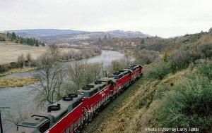
The Klamath River does not curve sharply. The waterlevel track does nonetheless.
In the traffic concept of 1880s Southern Pacific, Hornbrook was the helper attachment station. Few miles north of this small town, the grade steepens to 3.3%. For any upgrade scenario, the following limits have to be considered:
- The example trains won't reach more than 60 mph. While the grade is normal for modern highspeed lines, the situation on such lines is different: The trains arrive at the bottom with a speed of 186 mph.
- Even with more powerful locos, as suggested, freight trains won't exceed 25 mph. This means, that eased curves have to be calculated with rather low superelevation.
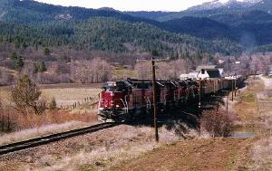
On the positive side, major parts of the track along Cottonwood Creek use a wide valley and are close to straight.
The Siskiyou Line in northernmost California.
For timetable calculation, no changes to the alignment are assumed.
