Speed-Zone 12:
Down to the Rogue Valley

Steinman to Ashland

North of Steinman, the route stays steep and curvy, with a grade of 3.3% and many curves of 574 feet radius. Unlike the pass climb with its loops, the author considers this part of the track to be improvable, but the comparison of cost and effect does not yield a very good result, and puts this part very low on the list. Due to the grade and low freight speeds, superelevation is as limited as on the pass route, and passenger train speed will be 43 mph.

Freight train climbing within a narrow valley, within forests.
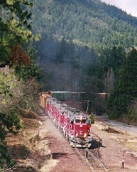
A CORP freight climbs up the grade from Ashland to Steinman

When entering the valley, the grade flattens to 2.2%, the curves get bigger, full superelevation can be used, and the trains would be able to speed up to 60 mph, for the last miles to Ashland. Unfortunately, there is a sharp reverse curve in the middle of the easy terrain. If any curve is worth to be straightened, it is this one.

Topo map shows one sharp reverse curve within easy terrain.
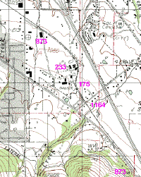
At Belleview, a single curve would cause a slowdown from 60 to 47 mph.

The time is calculated without any alignment change.

Achievable timing
Location Distance ...added up  Time elapsed Coast Starlight Average speed ...added up
Ashland 10 mi (16 km) 324 mi (521 km) 00:15 05:35 - 40 mph (65 km/h) 58 mph (93 km/h)
Steinman 13 mi (21 km) 314 mi (505 km) 00:20 05:20 - 37 mph (60 km/h) 59 mph (95 km/h)
MP 406.3 21 mi (34 km) 301 mi (485 km) 00:28 05:00 - 45 mph (73 km/h) 60 mph (97 km/h)
Willow Bridge 32 mi (52 km) 280 mi (451 km) 00:29 04:32 - 67 mph (108 km/h) 62 mph (99 km/h)
Edgewood 5 mi (8 km) 248 mi (399 km) 00:07 04:03 - 43 mph (69 km/h) 61 mph (98 km/h)
Weed 0 243 mi (392 km) 00:01 03:56 - - 62 mph (99 km/h)
Weed 4 mi (7 km) 243 mi (392 km) 00:06 03:55 - 42 mph (68 km/h) 62 mph (100 km/h)
Black Butte 12 mi (19 km) 239 mi (385 km) 00:14 03:49 - 52 mph (84 km/h) 63 mph (101 km/h)
Azalea 11 mi (18 km) 227 mi (365 km) 00:21 03:35 - 32 mph (52 km/h) 63 mph (102 km/h)
Dunsmuir 0 216 mi (348 km) 00:01 03:14 05:05 - 67 mph (108 km/h)
Dunsmuir 26 mi (42 km) 216 mi (348 km) 00:44 03:13 ??:?? 36 mph (58 km/h) 67 mph (108 km/h)
MP 296 30 mi (48 km) 189 mi (304 km) 00:36 02:30 - 51 mph (82 km/h) 76 mph (122 km/h)
Redding 0 159 mi (256 km) 00:02 01:54 03:15 - 84 mph (135 km/h)
Redding 25 mi (40 km) 159 mi (256 km) 00:17 01:52 ??:?? 89 mph (143 km/h) 85 mph (137 km/h)
MP 233 10 mi (16 km) 134 mi (216 km) 00:09 01:35 - 68 mph (109 km/h) 84 mph (135 km/h)
Red Bluff 0 124 mi (200 km) 00:01 01:27 - - 86 mph (138 km/h)
Red Bluff 39 mi (63 km) 124 mi (200 km) 00:26 01:26 - 91 mph (146 km/h) 87 mph (140 km/h)
Chico 0 85 mi (136 km) 00:01 01:00 01:56 - 85 mph (137 km/h)
Chico 44 mi (71 km) 85 mi (136 km) 00:29 00:59 ??:?? 91 mph (146 km/h) 87 mph (140 km/h)
Marysville WP 0 41 mi (66 km) 00:02 00:30 - - 86 mph (138 km/h)
Marysville WP 41 mi (66 km) 41 mi (66 km) 00:28 00:28 - 90 mph (145 km/h) 90 mph (145 km/h)
Sacramento 0 mi (0 km) 0 mi (0 km) 00:00 00:00 00:00 0 mph (0 km/h) 0 mph (0 km/h)


Unit conversion for text on this page.
574 feet radius 175 m radius 10 degrees of curvature
43 mph 69 km/h  
60 mph 97 km/h  
47 mph 76 km/h  

about this document            Hans-Joachim Zierke            © notice            Thank you


Last modified: 2004-05-18